Advanced Techniques Every GIS Professional Should Know
June 8, 2023 2023-06-08 9:07Advanced Techniques Every GIS Professional Should Know
Advanced Techniques Every GIS Professional Should Know
Geographic Information System (GIS) technology has transformed the way we analyze and interpret spatial data. As GIS professionals, we have the power to unlock valuable insights and make informed decisions by harnessing the advanced techniques of spatial analysis. By leveraging the full potential of spatial analysis, we can uncover hidden patterns, reveal meaningful relationships, and gain a deeper understanding of the world around us. In this article, we will explore some advanced techniques that every GIS professional should know to unleash the power of spatial analysis.
Related: Top Ten Reasons Why Professionals Should Get GIS training

Advanced techniques every GIS professional should know
Here are some advance techniques every GIS professional should know to unleash the power of spatial analysis:
Spatial interpolation
Spatial interpolation is a technique used to estimate values at unknown locations based on the values observed at known locations. It’s particularly useful when dealing with incomplete or irregularly distributed data. With spatial interpolation, GIS professionals can generate continuous surfaces or maps that represent the spatial distribution of a specific phenomenon, such as temperature, pollution levels, or population density. Popular interpolation methods include inverse distance weighting, kriging, and spline interpolation.
Related: Harness the Power of Spatial Analytics
Network analysis
Network analysis allows GIS professionals to model and analyze complex networks, such as road networks, utility networks, or transportation systems. By considering the connectivity and relationships between network elements, we can solve a variety of spatial problems, including route optimization, facility location, and service area delineation. Network analysis techniques, such as shortest path analysis, network allocation, and network-based spatial clustering, enable us to make informed decisions that optimize resource allocation and enhance efficiency.

Geostatistics
Geostatistics is a powerful set of techniques for analyzing spatial variability and understanding the patterns of spatial data. It combines statistical analysis with spatial relationships to model and predict values at unsampled locations. GIS professionals can use geostatistical techniques, such as variogram analysis, kriging, and co-kriging, to quantify spatial autocorrelation, map spatial uncertainty, and generate accurate predictions. Geostatistics is widely applied in fields like environmental monitoring, natural resource management, and precision agriculture.
Hotspot analysis
Hotspot analysis, also known as spatial clustering analysis, helps identify areas with significantly high or low values of a particular phenomenon. By analyzing the spatial distribution of data, GIS professionals can identify clusters or hotspots of events, patterns, or anomalies. Hotspot analysis techniques, such as Getis-Ord Gi* statistic and kernel density estimation, allow us to uncover spatial patterns that may not be apparent briefly. This knowledge is crucial for understanding crime patterns, disease outbreaks, urban development, and resource allocation.
Multicriteria decision analysis
Multicriteria Decision Analysis (MCDA) combines multiple criteria or factors to support decision-making processes. GIS professionals can use MCDA techniques to evaluate and compare alternative scenarios or locations based on various criteria, such as accessibility, suitability, or environmental impact. By assigning weights to different criteria and performing spatial overlay analysis, we can generate decision surfaces or maps that help prioritize and optimize spatial decisions. MCDA is widely used in urban planning, site selection, and environmental impact assessment.

3D analysis
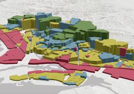
With the advent of 3D GIS technology, GIS professionals can now perform advanced 3D analysis and visualization. By incorporating elevation data, building models, and terrain information, we can analyze and simulate real-world scenarios in three dimensions. 3D analysis techniques, such as viewshed analysis, volumetric analysis, and 3D network analysis, provide valuable insights for urban planning, line-of-sight analysis, flood modeling, and infrastructure design. The ability to analyze data in three dimensions adds an extra dimension of realism and accuracy to spatial analysis.
Related: Five Powerful Capabilities of ArcGIS 3D Analyst
In conclusion, spatial analysis is a fundamental component of GIS that empowers professionals to extract meaningful information from spatial data. By mastering advanced techniques, you can unleash the power of spatial analysis.
Click here to buy ArcGIS products.


