
Streamlining Field Operations with ArcGIS
Efficient field operations are critical for organizations managing assets, infrastructure, or …

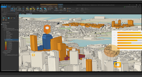
How ArcGIS and Autodesk Are Transforming Construction Site Inspections
The construction industry is evolving rapidly, and digital transformation is playing …

Location – Driven Market Insights: A Roadmap to Intelligent Business Development!
Location intelligence is the methodology of deriving insights from location data …

Automation of Dynamic Data Updates from Google Spreadsheets
Automation of data is a rising trend in the GIS industry …
Managing, Processing and Analysis of Drone Imagery with Site Scan for ArcGIS
Site Scan for ArcGIS is an end-to-end cloud-based drone mapping tool …

Turning Drone Imagery to Geospatial Intelligence
Drones are changing how we work in practically every aspect, and …

Evaluating Urban Development Plans with ArcGIS GeoPlanner
Due to limited land resources, development demands, and intricate planning procedures, …