Imagery Analysis in ArcGIS Pro
August 8, 2022 2022-08-08 9:33Imagery Analysis in ArcGIS Pro
Imagery Analysis in ArcGIS Pro
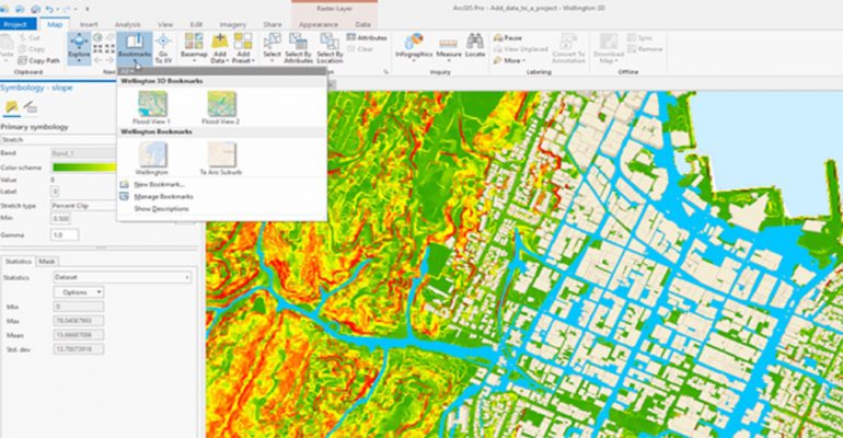
You can manage, analyze, visualize, and share your raster data using ArcGIS Pro. The options offered by ArcGIS Pro are contextual, which means they are dependent on the type of data you have picked. When working with numerous photos or mosaic datasets, the ribbon options will only affect the layers you’ve selected in the Contents window. When you pick an image in the Contents window, the Appearance and Data tabs appear under the Raster Layer contextual tab on the ribbon. In this article, you will get more insights on what Imagery Analysis in ArcGIS Pro entails and an option to register for the course.
Imagery analysis is a 3-day course that not only focuses on the analysis but also in interpretation by extracting information from imagery. For instance, if you are interested in land use or land coverage, ArcGIS Pro has many tools that classify imagery. You can choose to classify image pixels or segmented objects using parametric or machine learning classifiers.
Now you can use one software in analyzing vector and raster data. Our remote sensing experts have come in handy to add different tools and extensions in ArcGIS Pro.
In this course, some of insights are:
- Introduction to Raster in ArcGIS Pro
- Raster Functions in ArcGIS Pro
- Change detection using raster functions
- Image classification techniques
- Classification workflows
- Segmentation
- Training the classifier
- Classification evaluation
At the end of this course, you will be able to:
- improve picture display and change detection, using dynamic raster functions.
- perform supervised, object-based picture categorization and evaluate the findings’ accuracy.
- work with digital elevation models and other derived information items.
Although this course is designed for GIS professionals and imagery analysts, other sectors including natural resources, health, and government agencies who need to extract useful information from satellite imagery, data obtained by unmanned aerial vehicles (UAVs), and other imagery formats can train for this course. Common examples of imagery use include damage assessment, disaster recovery, and a forest canopy evaluation.
The course covers the fundamentals of remote sensing and imagery, as well as how to visualize and analyze imagery with ArcGIS Pro and the ArcGIS Image Analyst extension. You will get hands-on experience working with a range of visual data in realistic circumstances. The training prepares participants to use acceptable methodologies and recommended workflows to provide meaningful information that supports mission planning and tactical operations.
The course also offers beginners, intermediate and advanced students in GIS and Remote sensing an opportunity to enroll. All you need are the basic skills of ArcGIS pro / ArcMap, and you are good to go.
Our different clients and partners have utilized this spatial imagery analysis tool in meeting their needs in different imagery related workflows.
You can be able to sign up for physical or virtual course here; (website imagery analysis details) here.
For more information, contact Esri Eastern Africa product department: products@esriea.com or visit our E-store https://ea-store.esri.com/en-ke/store/overview
By:
Rachael Mutuli (Content Marketing Writer)
Lydiah Biri (Product Engineer)


Comment (1)
Manesh
Greaat